Mission & Goals
The San Dieguito River Valley Regional Open Space Park Joint Powers Authority (also known as the San Dieguito River Park JPA) is the agency responsible for creating a natural open space park in the San Dieguito River Valley. The Park extends from the ocean at Del Mar to Volcan Mountain, just north of Julian.
The San Dieguito River Park JPA was formed as a separate agency on June 12, 1989 by the County of San Diego and the cities of Del Mar, Escondido, Poway, San Diego, and Solana Beach. It was empowered to acquire, plan, design, improve, operate, and maintain the San Dieguito River Park.

Mission Statement
Goals
- Preservation of Open Space – Establish a continuous open space corridor throughout the length of the focused planning area that preserves natural habitats, protects linkages for wildlife movement and provides compatible areas for recreational opportunities.
- Conservation of Sensitive Resources – Preserve the existing natural character, visual quality, and sensitive resources of the open space corridor, including the preservation, enhancement, and protection of sensitive coastal wetlands, hillsides, riparian and other freshwater habitat, native vegetation and historical and cultural resources.
- Protection of Water Resources – Optimize the water quality and quantity of all groundwater resources and surface water bodies within the planning area through water conservation, erosion control, pollution control and restoration.
- Preservation of the Natural Floodplain – Maintain the 100 year floodplain and sheetflow areas within the planning area in an open configuration with a natural channel and provide adequate area for the normal stream waters to meander through the floodplain. The 100 year floodplain and sheetflow areas will be preserved for open space uses such as recreation, wildlife habitat or agriculture.
- Retention of Agricultural Uses – Retain and encourage responsible agriculture in appropriate areas.
- Creation of Recreational and Educational Opportunities – Create a scenic trail and interpretive system and establish recreational areas including water related uses, which are compatible with the natural values of the river system.
Vision
Like the river that begins in the ancient forests of Volcan Mountain and runs through rich farmlands of the San Dieguito River Valley to the San Dieguito Lagoon and the Pacific Ocean, the vision of the San Dieguito River Park reaches out to the future with ideals of preservation and protection of the beautiful rural character of the San Dieguito River Valley.
From the Coast to Crest Trail that will someday link the ocean in Del Mar to the summit of Volcan Mountain – about 70 miles – to the celebration and preservation of our local heritage and natural resources, the San Dieguito River Park is creating recreational and educational opportunities that interface gently with nature.
But creating the San Dieguito River Park will take many years. Over 50 percent of the land within the planning area of the Park is in public ownership now. Some of those areas will be set aside as habitat preserves. Appropriate recreational activities for the remaining public areas are being planned and implemented now. Some trail segments are already open to the public.
For funded planning projects, workshops will be held to determine where park facilities should be placed. It is Park Policy that private property rights (PDF) will be respected and the Park will not infringe upon those rights to implement its goals and objectives.
Board of Directors
The Joint Powers Authority Board of Directors is composed of two elected officials each from the County of San Diego and the City of San Diego, one elected official each from the cities of Del Mar, Escondido, Poway and Solana Beach, and one public member representing the Citizens Advisory Committee.
Citizens Advisory Committee (CAC)
The Citizens Advisory Committee is a standing committee of the Joint Powers Authority Board of Directors. It is responsible for advising the JPA Board on land use matters which directly impact the Park’s Focused Planning Area.
Focused Planning Area
The Focused Planning Area (FPA) is the area of focus for the San Dieguito River Park’s acquisition and planning efforts. It roughly corresponds to the viewshed of the San Dieguito River Valley and its tributary streams – that is, what you could see if you were standing on the valley floor. The six member agencies of the JPA have adopted the FPA as a regional park planning boundary.
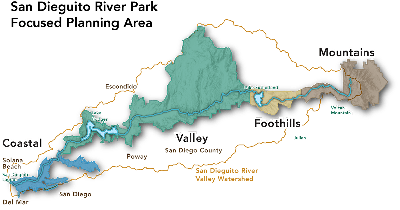
Preservation and recreation projects within the San Dieguito River Park FPA are limited to publicly owned lands and where private owners have provided legal access such as trail easements. Mere inclusion in the FPA does not indicate that private property is part of the Park and does not in any way affect the private property rights of the owner.