
NOTE: Our Google map is being updated.
Click the box with an arrow on the top left corner of the interactive trail map to bring out a list of all the trail segments on the map. Click on one of the trail segments from the list to highlight it on the map and bring up information about it.
The gaps are shown on the map as red lines, and some of the segments are concept alignments only with no public access.
Completed segments that are open to the public are the green lines. The purple lines are other SDRP trails open to the public that are not part of the Coast to Crest Trail. The SDRP Focused Planning Area boundary is the yellow line.
The status of the Coast to Crest Trail can also be viewed on our trails Story Map (Planned Trails) (link opens in new window). 49 miles of the 71-mile-long planned trail are complete today, but several trail gaps remain.
Or, click on one of the headings below to bring up more information about that trail section or gap.
Section 1: Beach to Polo Fields
This 3.50-mile section of trail is 71% complete, which includes the current 2.50-mile trail segment from Jimmy Durante Blvd. to El Camino Real.
There are two remaining gaps, described below.
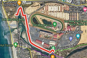
The gap begins at the Fairgrounds at Jimmy Durante Blvd. To go west to the beach will involve crossing Jimmy Durante Blvd., the Fairgrounds, as well as the railroad bridge and Camino Del Mar. A turn-around area on the Fairgrounds property just before the railroad tracks was identified in the Reach the Beach Feasibility Study.
What’s been done:
- A Reach the Beach Feasibility Study (PDF), done in 2012, studied various trail alignments, and recommended that a crossing both north and south of the river be constructed.
- Trail easements have been secured along a portion of the Fairgrounds property.
- A grant application for design of a north crossing was made, but not received.
- SANDAG has agreed to construct a railroad bridge undercrossing for the continuation of the Del Mar River Path trail on the south side of the river when the railroad bridge is replaced as part of the double-tracking project. Est. before 2030.
The Coast to Crest Trail will be constructed under a new El Camino Real bridge (to connect the existing trail segment on Horsepark to a new trail segment on Polo Fields) when the old bridge is replaced by the City of San Diego. Est. 2024.
Section 2: Polo Fields to Santa Fe Valley
This 4.8-mile section is 14% complete. The completed section travels through the County’s Lusardi Creek Preserve. The gaps are described below.
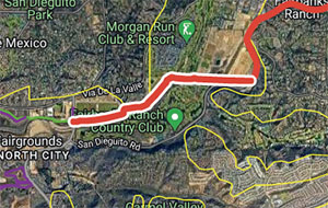
This City-owned property commonly known as the Polo Fields is now leased to Surf Cup Sports. Construction of this trail section is the responsibility of the lessee and connections are needed at both ends. The west end will be connected to the future trail underpass at El Camino Real. The east end of the trail will be connected to the Osuna Valley segment in 2023/4 (see next gap).
Progress made! Construction grant received in 2021, est completion 2024. At the east end of the Polo Fields, the trail is planned to cross the river to the south/east and connect to San Dieguito Road. This involves the construction of a 160-foot-long bridge and a short section of trail to reach San Dieguito Road.
What’s been done:
A Bridge Feasibility Study has been completed. The Study analyzed types of bridges that could be utilized, the environmental impacts associated with the bridge types and locations, and estimated cost. An important trail easement along private property was obtained in 2017. Permits and compliance with the California Environmental Quality Act (CEQA) and construction will be future steps.
The trail is planned along the San Dieguito Road road right-of-way through this section to the Black Mountain Open Space Park trail staging area. The trail will connect to the Lusardi Creek County Preserve. Planning is proceeding with County Public Works and Parks departments as a capital improvement project.
Section 3: Santa Fe Valley to Highway 78
This 22-mile section is 100% complete. This section goes through Santa Fe Valley, Del Dios Gorge, the north shore of Lake Hodges, past Sikes Adobe Historic Farmstead and Mule Hill, and through San Pasqual Valley. There are no gaps in this section.
Section 4: Highway 78 to Boden Canyon
This 5-mile section is 0% complete. The gaps in this section are described below. The map segment is a concept alignment only.
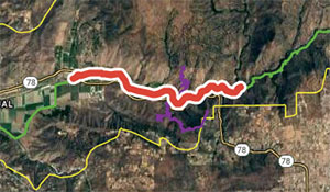
This gap extends from the existing San Pasqual Valley Staging Area (Bandy Canyon Rd. at Hwy. 78) to Boden Canyon. The first two miles is planned through orange and avocado groves on the farm leasehold. A general alignment has been scouted with the lessee. The last section is across rugged terrain.
Issues:
The west end of this gap requires crossing Hwy 78 and the east end is through rugged terrain.
This gap assumes that the trail is continuing on the north side of Hwy 78 from the existing Clevenger Canyon North Staging Area. A feasibility study was completed that evaluated several trail alignment alternatives through this rugged terrain.
This gap is an existing dirt road that would connect Gap 4.1 to the existing Lower Santa Ysabel Truck Trail. Some improvements are needed that will require agency coordination with the California Dept. of Fish & Wildlife and the City of San Diego, each of which own a portion of the road.
Section 5: Boden Canyon to end of Upper SY Truck Trail
Pamo Trail completed in 2019. This 12.6-mile section is complete, which includes the 3.3-mile-long Lower Santa Ysabel Truck Trail, 3.3-mile-long Pamo Valley segment, and the 4.9-mile-long Upper Santa Ysabel Truck Trail.
Section 6: Sutherland Reservoir to Santa Ysabel West
This 8.38-mile section is 0% complete. The gaps are described below. The map segment is a concept alignment only.
Section 7: Santa Ysabel West to Highway 79
This 2.7-mile section is 15% complete. The completed 0.40-mile section is within the County’s Santa Ysabel Open Space Preserve West. The mapped trail segment is a concept alignment only.
Section 8: Highway 79 to Volcan Mountain Trailhead
This 1.15-mile section starts at the Santa Ysabel Open Space Preserve trailhead at Farmer Road. Farmer Road connects the trailhead to Volcan Mountain Summit trailhead, but a separated trail is desired.
Page last updated January 28, 2019.